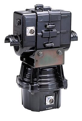
Monday, May 29, 2017

Home Station Build - Rotor / Software

If you will remember the blog post from last fall call Missing DX - Cause YOU'RE the DX I wrote about how I was in the process of building a home station. This is a drastic change for how I normally operate, portable holding an arrow - but there are certain advantages that you get from having a fixed station at the QTH, including resiliency to weather, remote operation, ability to run more power (buhahaha) and the ability to work "yourself" when you go out roving with a special event or club callsign. I've got a ton of upgrades going on, and I have no idea how many parts this may end up being, but I need to get what I'm doing documented for my own reference years from now, and for your benefit in case you have the same issues I have.  Anyway, here's where I'm at with a few things:


Rotor / Tracker

I managed to score a used Yaesu G-5500 from a fellow ham after trading him some stuff. I also picked up a LVB tracker at the same time, so instantly that gave me the ability to point my 'arrow on a tripod' actually AT the bird instead of fixing it one direction and waiting for the Satellite to go by. This was a pretty major upgrade for me.

Integration into SatPC32 was easy with the LVB, and now I've got computer control rig command and rotor adjustment all automatic. This is pretty sweet. Not having to have a flash card with all the frequencies, or numerous memories programmed in - the computer doses it all.


Signalink / 8 Pin Din

If you'll recall I had made my own audio cable out of a scrap piece of Cat5e I had laying around. Well I finally upgraded and got the actual RJ45 to 8 Pin Din rollover cable, so I can hook the Signallink into the Accessory port on the 821h. I had to tweak with the sounds levels (again, and always) on the Signalink to get it right, but I got it working without a whole lot of problems. Using the Accessory port is nice because I can still take manual control using the microphone and over ride any computer generated audio if I'm sitting there at the station.

LinPhone


I was using Skype for my VoIP software in my old model... however it just doesn't work so well with full duplex audio (that is talking and listening at the same time) which is kind of important for Satellite work. I also didn't like a lot of the bloatware that goes along with it being a Microsoft product, so I went hunting for an open source product that had better full duplex support. Clayton, W5PFG, suggested I take a look at LinPhone. After trying it for a week, I was hooked. It runs on the open source SIP protocol, and can work via direct connection, or via a registered proxy. Plus it has an Android App and works on multiple PC platforms, I've been very happy with it since I switched everything over, and don't have any plans on changing. 

Kep Updater Script

I like to automate stuff (duh) so of course I built a script that automatically updates the published TLE's for all the Satellites. I've actually been doing this manually for a while, but with perl and tasks schedulers I took it to a new level. What the script does is grab the 'amateur.txt' file from Celestrak, and the 'nasa.all' file from amsat.org, then parses out the TLEs for the birds I want to track, and puts them into a new file aptly called 'daves-picks-tle.txt' on my Google Drive Cloud Account. I can then point all of my PC's to this location (including my shack PC running SatPC32) for it's master set of TLE's for *just* the birds I care about. Add in a Windows Task Scheduler to run said script every morning at 3AM, and voila, I'm always using keps less than 24 hours old. 


Wanna see the source code? Click Me to Download from Google Drive

Karen's TimeSync

I was also having some issues with Doppler Drift in SatPC32, that I couldn't really explain. In the Manual for SatPC32, Erich mentions needing clock accuracy of 1 second or less, as well as very recent keps to keep your accuracy spot on. Windows is notoriously bad for clock drifting, even with NTP enabled, so I went looking for a 3rd party program, and found Karen's TimeSync for Windows that seems to do the trick. I've got my PC pointed at the time.nist.gov NTP source, and I ask for an NTP update once an hour. 


That seems to have solved and clock drift issues, and has helped (There are still issues I'm fighting, more on that in an upcoming entry) keep the Doppler correction on track. The program has a few flakes in it, like I have restart it after running for a weeks straight, but it seems to get the job done. I may write a super lightweight script in perl to do this at some point down the line, but for now it works. 

More!

I've still got lots more to talk about. I've got new antennae on the way, I'm working on polarity switching, and I haven't even mentioned my remote automation relays I've got setup, or my problems with automatic doppler correction, voltage issues, and all sorts of other fun...

 But that's it for this entry, more next time!

Monday, May 22, 2017

The Atomic AMSAT Roadtrip - Part II

Covering everything that we did on Saturday will make this the longest blog entry ever. So I'm just going to focus on the visit to Trinity, since that was the Apex of the entire trip, and I want to do the visit justice, Part III will cover everything after we left the Missile range.

We woke up early at 6AM the next day, at our Valley of Fires Campground Base. After the long drive and crazy operating the day before, we probably should have gotten more sleep, but the gates at Stallion Army Air Field opened at 8AM promptly, we had roughly an hour drive to get there, and you DON'T show up late, or else you end up in a line miles and miles long to get thru security. We also had a long day planned ahead of us, so getting to the site early was in certainly going to be required.


We broke camp, grabbed quick showers, and headed west deep into DM63 and along the northern side of WSMR. After some driving we made it to the Stallion Gate, and found while we were still early, there were a lot of people in front of us. Will definitely get up another 30 minutes earlier if we do it again next time. Once we got in line, we waited for security to start moving people thru. With nothing else better to do, we obviously had to go live on Periscope:
It wasn't too horribly long and the line started moving. We got thru security about 8:20AM MDT and snapped a nice cheery picture at the entrance to the range itself, because once we entered the secure area, no more pictures were allowed until we reached the trinity site itself.


After about 30 minutes of driving out across the range, we finally started seeing the brown National Historic Site markers that designated the Trinity Site. We parked in the well maintained and defined parking lot, and started our walk. There were large chain link fences around the entire area, with plenty of large 'RADIOACTIVE MATERIAL' signs on them.


Right outside the main gate to the fence was the remaining part of JUMBO - the container they almost used to try and contain the explosion if it was a dud, so we of course stopped for a picture.


After hanging out with Jumbo, we headed to Ground Zero. It was clearly marked for us. 


Took some video as we walked:


And of course once we got there:


I did the required Picture next to the Ground Zero Obelisk:


And took a bunch more pictures...


We then jumped on the bus and headed to the nearby McDonald Ranch House, which is where the final assembly of the bomb was conducted just before the test. And of course, took a bunch more pictures there:


After several hours exploring, we headed back to the parking lot. Said goodbye to some friends, and then headed out. We had a lot more driving to do that day, and we needed to get a good move on. 

I was asked by a lot of people what I felt about visiting the site. Normally I do things and go places because it's some sort of awesome crazy adventure. I'm not so sure those words are apt about Trinity. The technology that was developed at Trinity killed hundreds of thousands of people in Japan 3 weeks later. Nuclear testing killed dozens of government technicians, poisoned hundreds of Marshallese Islanders, and isotope development and Nuclear Power led to the disasters in Chernobyl and Fukashima. It has also led to power sources that keep the lights on for 20% of Americans, and saved the lives of countless tumor and cancer victims thru Nuclear Medicine. I've often heard of Atomic Technology being referred to as a Genie, and there's no putting it back in the bottle once it's out. Visiting Trinity was like going to the place where we first rubbed that lamp, and I'm glad I got to see it first hand. 

Monday, May 15, 2017

My AMSAT Etiquette - Rule 2


Rule 2: I let the DX have the bird

The Things you find Google Image Searching a Term
When operating, if I hear a rare station, a rover, a portable operator, or anything that is generally uncommon, I will typically let them have the bird and make as many contacts as they can. This is generally the same idea behind letting a DX keep an HF frequency, except on the Satellite there is a finite amount of time they will be able to make contacts, and it's important to give them as much time as possible. Even more so, since FM repeater birds typically are considered 'easier' to work, and require less equipment for the operator, these are more commonly used by rovers or portable operators who may not be full time AMSAT ops, or may have only a small amount of gear to work with. 

In the SOTA world we have a saying - 'The Activator is King' - I think that applies in the Satellite world too.. the DX is king. If someone is somewhere rare, I can wait for another pass to say hi to theguy a few grids away who I hear all the time - ESPECIALLY if I'm on a single channel FM bird. If I'm on a linear bird, and I just *have* to ragchew with someone, I'll spin my dial way off of center, reduce my power to minimum (to make sure the DX has as much of the transponder's power as they can) and then talk to my buddy there.

When I try to think of an exception or a caveat to this rule, and I'm coming up blank. What do you think? Any exceptions or reasons you shouldn't let a rare DX have the bird? 

Monday, May 8, 2017

CM93 Part 3: The Channel Islands National Park

This is the final piece on the trip to Santa Rosa, and CM93. And It's going to be a bit different from other things you read on this site. Yes, the trip was primarily done to activate the rare grid of CM93, but with the National Parks on the Air celebration of 2016 - the plan was rushed to make sure it would happen for the event, instead of waiting until another year. The Channel Islands are unlike any other place I've been in the lower 48 states... Walking around on Santa Rosa reminded me of South Texas, Wyoming, and the Washington Coast, all at one time, and all in the course of a few miles. Our National Parks are a treasure that we're lucky to have as Americans, and this entry will talk about what we saw when we packed our radios away.

The Channel Islands are actually a newer addition to the National Park System. For many years they were owned by Cattle Ranchers who used them as a fence-less open range area, for grazing purposes. They would bring over young herds on barges, let them forage on the Island for a while getting fat, then take them back to the mainland for sale. While an interesting use of the land, there was so much more than could have been done with them. Eventually thru the trials of time the Islands found their way into the hands of the National Park Service, who have developed them into a wilderness only miles away from one of the most densely populated areas of the country in Southern California.

On our trip, Friday and Saturday was about operating. Yes, we climbed Black Mountain, and explored the interior a bit, but our focus was on making QSOs. Sunday morning we changed gears. We secured our camp very early in the morning, locked up the radios, dropped off our heavy packs at the dock, and headed towards 'Lobo Canyon' on the north central part of the Island.


I took this picture on our hike to the Canyon as the Sun came out. It reminded me very much of the high plains country of West Texas or Wyoming.


The hike to Lobo paid off quickly, as we spotted one of the rare Island Foxes native to Santa Rosa, but rarely are seen by visitors near the campground or dock.


Shortly after the fox sighting, we can to the first of what I can only describe as a 'Badlands' or a 'Scarp' region. Since the majority of the island is a raised rounded dome, where water would flow towards the ocean, these little canyons would form - leaving behind some stunning rock and dirt formations. 


A little ways after the Scarp formation, we began the descent into the Canyon. A long switchback along the Canyon wall slowly dropped us 500' in elevation, and we entered Lobo. 


We stopped for a selfie at the sign marking the beginning of the Lobo Canyon Trail. At this point is was 1030AM and we have already hiked something like 8 miles. 


The Canyon started as a more arid environment, but as we progressed we started finding greenery and water. 


Amongst the green and slowly descending elevation were multiple rock overhangs and cave dwellings that would have served well as shelter to earlier peoples. 


As we kept walking, I got the GoPro out, and took some footage. I've finally finished processing all this footage, and present it to you here:


After exploring the confluence of the Canyon and the Ocean, we started back for the Dock. Our boat was picking us up at 1500 sharp, and we had a flight home the next morning. After getting on the boat, scoring some pizza and beer, we relaxed for the ride home. About halfway back, while along the coast of Santa Cruz Island, the Captain said something about 'The Painted Cave'. Since this obviously sounded awesome, we both ran to the front of the boat and saw what was referred to as the 'Largest Sea Cave in the World, by people who record these sorts of things"


And of course, took some quick video with the phone


Seeing the cave was really cool, and a fitting end to the journey. The combination of rock and water, was really what shaped and made the Channel Islands what they are. It's interesting to think of the combinations of very unique factors that led me to this place. I suppose that's what its all about though - taking advantages of the opportunities when they arise, and then making the most of the moment. I did that in the Channel Islands, and I hope to come back some day. 

Monday, May 1, 2017

Tips from the Field - Grid Mapping Tools

One of the emails I had a while back from a reader was asking for information about roving, from the perspective of how do you know where you are in a grid. It occurred to me, that putting together a comprehensive list of Grid and Mapping tools would be a worthy Tech Blog Entry. So here we go.


QTH Locator by F6FVY


I love this tool. You open a webpage. Punch in the grid you want (In either 2, 4, or 6 character sizes) and it draws a box around your requested area in Google Maps. You can toggle among standard road map, terrain, and Satellite images. When planning a road trip to random places, I will spend hours sometimes using this tool to make sure I hit the grids I'm after. It's a true thing of beauty. Check it out Here.

SOTA Mapping Project


A close second to the QTH locator tool is the SOTA Mapping Project - which is alot busier, but also gives a ton more information. While this tool is obviously more tailored for Summits on the Air Activators and Chasers, the grid tools that are over-layed onto Google Maps are fantastic. Plus, if you like going up up mountains, it's pretty much the de-facto information source. 

HamGPS


Once I'm in the field, how do I know where I am? I use an Android App called HamGPS on my phone. It shows me GPS, time, date, lat/long, altitude, and will also display Maidenhead grids If I want them. It's dang useful as well for finding exact grid lines, and grabbing a screen shot of it for evidence later.